Measuring the mighty Mississippi: Modern discharge data collection using ADCP, water quality, and autonomous platforms
Introduction
The Mississippi River, often called the backbone of America, has long been a vital artery for commerce, agriculture, and communities spanning multiple states. Measuring the river’s discharge—the volume of water flowing past a point per unit time—has been a crucial endeavor for over a century, enabling flood forecasting, navigation safety, water resource management, and ecological studies. The U.S. Geological Survey (USGS) has played a central role in this ongoing effort, deploying a network of stream gages to monitor the river’s dynamic flow. The USGS has been collecting discharge data on the Mississippi since the late 1800s.
Historically, gauging discharge on the Mississippi presented formidable challenges. In the 19th and early 20th centuries, measurement methods were rudimentary, relying on manual operation of mechanical flow meters, floats, and calculations based on river stage and cross-sectional area. The river’s vast width, shifting channels, strong currents, and sediment loads made accurate measurement difficult. A memorable example occurred during the 1927 Great Mississippi Flood, where gauging stations struggled to provide timely data amid catastrophic flooding, underscoring the need for more advanced and reliable monitoring.
Today, the USGS operates about 37 stream gages along the Mississippi River, from its headwaters in Minnesota to its mouth near New Orleans. Discharge is typically measured using a combination of stage (water level) sensors and velocity measurements. Acoustic Doppler current profilers (ADCPs) and other advanced instruments capture water velocity profiles, which, combined with cross-sectional area data, provide precise discharge estimates. However, the river’s complexity—marked by tidal influences near New Orleans, sediment deposition, and engineered levees—makes measurements there especially challenging.
Near New Orleans, USGS gaging stations must contend with factors like backwater effects—water held or pushed upstream—from tidal influences from the Gulf of Mexico, saltwater intrusion, and rapidly changing flow conditions due to storm surges or controlled releases from upstream dams. These complexities require sophisticated monitoring techniques and frequent calibration to ensure data accuracy, which is critical for managing flood risk and supporting the region’s extensive levee system.
Case study
In October 2025, Hydrologists and Hydrographers from SonTek, a Xylem brand, used a state-of-the-art autonomously operated vessel manufactured by Surfbee, Ltd. to perform an ADCP gaging near downtown New Orleans (Figure 1). The objective of the measurement was two-fold: to test the capabilities of the remotely controlled/autonomous platform, and to also push the limits of the SonTek-M9 ADCP for measuring discharge in a river of this size. In addition, the Surfbee hull had second moonpool to house a YSI EXO Sonde to collect water quality data along the measurement transect. Figure 2 shows a close-up of the Surfbee equipped with both instruments installed.
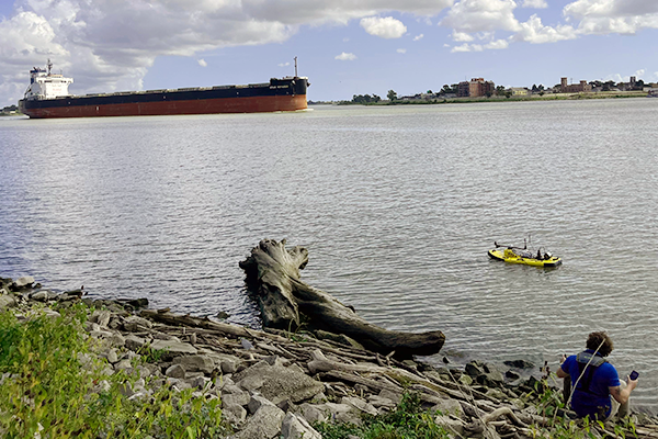
Figure 1. Surfbee Seeker outfitted with a SonTek-M9 and YSI EXO Sonde on the Mississippi
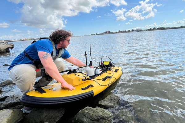
Figure 2. Systems Engineer, Shawn Sneddon, prepares to deploy the Surfbee equipped with a SonTek-M9 and PCM, YSI EXO Sonde, and Surfbee data logger.
The Surfbee surface water vehicles are specifically designed for use with Acoustic Doppler Current Profilers (ADCPs), including the SonTek-RS5 and SonTek-M9, bringing a new level of autonomy, precision, and safety to discharge measurements and acoustic surveys. Surfbee vehicles also have the ability to equip the YSI EXO Sonde to collect water quality data, though the following cases focus on discharge. With on-board Global Navigation Satellite System (GNSS) receivers for navigation and heading, live video streaming, and real-time adaptive speed and heading control, Surfbee vehicles can measure high-resolution transects navigating with exceptional precision and repeatability—even in hard-to-reach locations and difficult flow conditions.
Moving boat measurement across the Mississippi
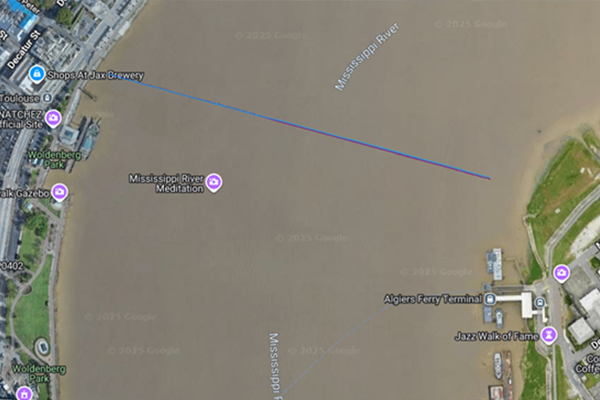
Figure 3. Map of transect across the Mississippi. Purple and blue lines indicate ship track via GGA and VTG GNSS stings, respectively.
Standard moving boat ADCP measurement procedures recommend pairs of reciprocal transects back and forth across the channel cross section, including at least 4 transects in total. Figure 3 shows the measurement transect performed with the Surfbee/M9/EXO. However, in cases where channels are extremely wide, or flow conditions are flashy, one or two transects is all that is possible. In this case, two transects were completed, but the second one (returning to the starting bank) deviated from best practices due to a large barge obstructing the cross section. Because of this, one good transect is shown in the data in Figure 4.
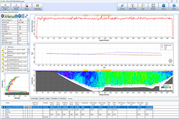
Figure 4. Screenshot of SonTek RSQ Software summarizing the measurement transect.
While bottom-track was available throughout the transect, some moving bed was expected for a river of such flow and size. The Surfbee onboard dual-head helical GNSS receivers and GNSS-based compass heading were used directly and incorporated seamlessly into the M9 RiverSurveyor Live software during data collection, allowing the user to bypass bottom-track issues and high compass magnetic interference. The Surfbee’s autonomous features were used to maintain a straight, steady course across a wide (700 m / 2297 ft) transect, something that improves ADCP measurement quality drastically and not possible before. The M9 data was then opened and post-processed in SonTek’s latest RSQ software. After taking advantage of other RSQ post-processing features like sub-sectioning and applying USGS Extrap, the final flow (Q) valued was calculated at 6949 m^3/s (245,158 ft^3/s), matching closely with the USGS gage (Belle Chasse) downstream of the site. The M9 measured a maximum channel depth of about 40 m (131 ft).
Flow data insights and challenges
The transect is the widest autonomous surface vehicle measurement on the Surfbee to date, measuring at almost 700 m (2297 ft). The autonomous driving features of the Surfbee helped immensely to maintain a steady speed across the transect along a straight pre-programmed line. With extremely wide cross sections like those on the Mississippi, driving a boat by sight from the bank gets incredibly difficult as the boat approaches the opposite bank. The onboard video feed from the vessel aided in navigating near the end edge, where the boat was nearly impossible to see. The onboard GNSS was able to hold position stationary at the far edge to collect good velocity data at that location, often very difficult with other techniques (e.g., radio-controlled).
The crossing proved to be risky due to the large distances, heavy flow, and boat traffic. While chances of collisions were avoided, direct line of sight is often compromised due to a large barge obstructing the view of the Surfbee by the operator on the bank running the computer collecting data. When this occurs, the user may notice communications drop-outs from their M9 ADCP. The M9 has a built-in data recorder which preserved the data in this case when communications were interrupted near the opposite bank. Even without external input, the M9 will continue collecting data, and users are able to download data off the M9 recorder once the measurement is already completed. In this case, due to increased barge traffic, the transect back required triple the boat speed for the return to the start bank, and RSQ software was used to separate the two transects and get an accurate discharge value for the first complete transect. With these extra tools and options, users can maximize their chance of obtaining a high-quality, accurate measurement even under challenging conditions.
Cross-channel surface EXO Sonde data
The Surfbee was also equipped with a YSI EXO Sonde during the measurement, allowing for surface water quality data collection along the transect. The EXO used in this measurement was equipped with temperature, conductivity, pH, turbidity, and dissolved oxygen. Figure 5 shows the results plotted with time along the transect shown in Figure 3.
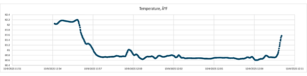
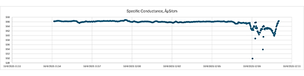
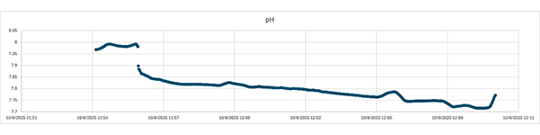
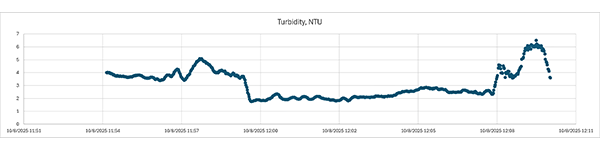
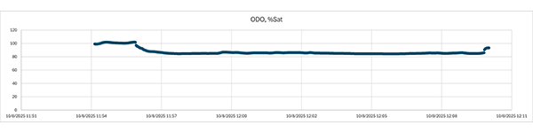
Figure 5. EXO Sonde data along the transect. From top to bottom: Temperature, Conductivity, pH, Turbidity, and ODO.
The EXO Sonde data were directly fed into the Surfbee and recorded using its on-board data logger. The data logger creates a CSV file containing the EXO Sonde data, along with timestamps and latitude/longitude from the Surfbee GNSS.
Plots in Figure 5 run from west to east with time. Generally, water quality parameters show differences near the banks compared to the center of the channel—a common occurrence on waterways with man-made infrastructure along banks.
Conclusion
The recent Surfbee measurement on the Mississippi River near New Orleans highlights how advanced technology is transforming river discharge monitoring. By deploying an autonomous surface equipped with the SonTek-M9 ADCP and YSI EXO Sonde, the team was able to capture precise flow and water quality data across an impressively wide 700-meter transect—something that would have been much more challenging and time-consuming with traditional methods. The autonomous navigation and onboard GNSS capabilities ensured steady, repeatable measurements, even in difficult conditions with heavy boat traffic and strong currents.
This case not only demonstrated the reliability of combining the Surfbee platform with SonTek and YSI instruments for large river applications but also highlighted practical challenges such as communication strategies during busy traffic and the need for flexible post-processing to ensure data quality. The addition of water quality monitoring via the EXO Sonde provided valuable complementary insights into temperature, conductivity, pH, turbidity, and dissolved oxygen variations across the channel.
Overall, this measurement effort reflects how innovative, autonomous solutions are helping hydrologists and water managers better understand complex river systems like the Mississippi. These advancements enable safer, more efficient data collection that supports critical decisions around flood management, navigation, and ecosystem health in one of America’s most important waterways.